Introduction
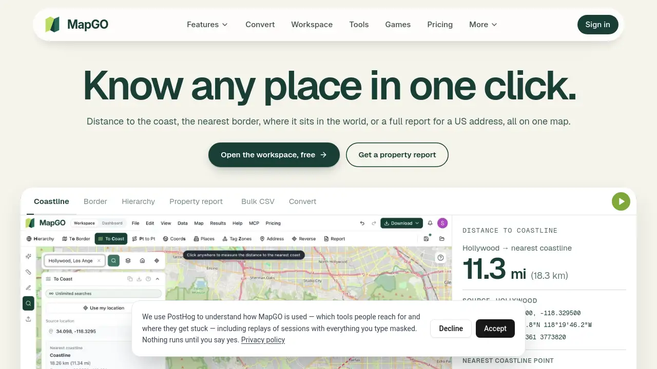
MapGO is an online mapping platform that turns coordinates into answers. It offers professional online mapping services and GIS data software for distance checks, geospatial analysis, and bulk CSV processing. Users can look up locations, create property location reports, measure areas, and convert map files in a browser. Coordinate lookups are free, and the platform covers 254 countries and territories. This MapGO review explains what it does, who it is for, and how it works.
What is MapGO?
MapGO is a browser-based geospatial mapping platform designed to help people answer location questions without installing desktop GIS software. It combines global boundary and coastline datasets with public data sources to calculate distances, identify administrative hierarchy, and produce reports. As GIS data software, it supports common map formats and provides tools for coordinate lookups, area measurement, map drawing, and file conversion. The platform solves a practical problem: location data is often locked in specialist tools or scattered across sources. MapGO brings many of those answers into one online mapping service. It suits property researchers, planners, analysts, students, developers, and anyone who needs quick geographic context. Because many coordinate lookups are free, MapGO also works as a set of free GIS tools for simple tasks.
Key Features of MapGO
Property Location Report
For any US address, MapGO creates a downloadable PDF covering 26 categories such as natural hazards, FEMA flood zones, wildfire exposure, schools, housing market, census figures, and crime. Each figure names its source, helping users investigate the surrounding area.
Global Location Hierarchy
Enter coordinates and MapGO returns continent, country, region, and district levels. The dataset covers 254 countries and territories, with thousands of districts and sub-regions for accurate geographic context.
Distance to Coast and Border
This distance calculator shows how far a point sits from the nearest coastline or border. Users can also measure point-to-point distances and initial bearings between places such as Paris and New York.
Area Measurement
Draw a shape on the map and MapGO calculates its area in acres, hectares, or square metres. This supports quick site checks without needing full GIS data software.
GIS File Conversion
MapGO can convert Shapefile, GeoJSON, KML, KMZ, GPX, CSV, GeoPackage, FlatGeobuf, SQLite, GML, DXF, MapInfo, and File Geodatabase. Users can check files on the map, choose output formats, and reproject to another coordinate system.
Map Drawing and Sharing
Add markers, lines, polygons, and labels to a map, then export or share the result. This makes the geospatial mapping platform useful for simple annotations and presentations.
API and MCP Access
The same lookups are available through a REST API on RapidAPI and an MCP server for AI assistants. Developers can build location answers into their own tools with real measurements.
Bulk CSV Processing
Paid plans add bulk CSV processing for larger coordinate workflows. This helps teams handle many locations at once instead of checking them one by one.
Use Cases for MapGO
Property Research and Due Diligence
Buyers, agents, and analysts can request a property location report for a US address. The report describes hazards, flood zones, schools, crime, and market context, while noting that it is not an appraisal or inspection.
Environmental and Hazard Screening
Planners and researchers can review wildfire exposure, wetlands, water, elevation, Superfund sites, and flood data. MapGO presents this geographic context in one place with named sources.
Site Selection and Distance Analysis
Businesses and urban planners can use the distance calculator to compare locations against coastlines, borders, and each other. Point-to-point measurements and bearings support early site evaluation.
GIS Data Conversion and Cleanup
GIS professionals can convert GIS files between Shapefile, GeoJSON, KML, GeoPackage, and other formats. This reduces friction when sharing data across different systems.
Education and Research
Students and teachers can explore location hierarchy, coordinates, and distances with free GIS tools. The browser-based design keeps technical setup low.
AI Assistant Location Queries
With the MCP server, AI assistants can answer location questions using MapGO measurements. This is useful for workflows that need verified geographic context.
How to Use MapGO
- Open the MapGO website and choose a tool, such as Location Hierarchy, Distance to Coastline, Measure Area, or File Convert.
- Enter coordinates, type a US address, or drop a pin on the map. Free coordinate lookups work without an account; a free account adds address search.
- For a property location report, select a US address and click Create report. MapGO gathers data around that point.
- Review the map result or download the PDF report. Check the named sources for any finding that matters.
- For file conversion, upload a Shapefile, GeoJSON, KML, or other supported format, select output formats, and download the converted files.
Target Audience for MapGO
- Real estate professionals, buyers, and property researchers
- Urban planners, site selectors, and environmental analysts
- GIS professionals and geospatial data teams
- Developers who need a REST API or MCP location service
- Students, teachers, and academic researchers
- AI assistant users who need location-aware answers
Is MapGO Free?
MapGO has free and paid options. Individual coordinate lookups are free, and some tools work without signup. Property reports, larger conversions, and bulk CSV processing use plan allowances or credits. Credits never expire and can cover files up to 5 GB. The API on RapidAPI is priced separately. Check the official Pricing page for current limits.
| Plan | Price | Features |
|---|---|---|
| Free | $0 | Free coordinate lookups, location hierarchy, distance to coast or border, basic map tools, no signup for some lookups |
| Free account | $0 | Adds address search and account-based access |
| Paid plans / credits | Varies | Property location reports, larger GIS file conversion, bulk CSV processing, higher limits; credits never expire |
| API on RapidAPI | Separate pricing | REST API lookups for developer integrations |
MapGO's Pros and Cons
| Aspect | Pros | Cons |
|---|---|---|
| Pricing | Free coordinate lookups and no signup for some tools | Property reports and bulk processing require paid plans or credits |
| Features | Combines reports, distance tools, area measurement, conversion, and API access | Property reports cover US addresses only |
| Ease of use | Browser-based, no GIS software installation required | Advanced GIS users may want deeper desktop analysis |
| Data transparency | Sources are named in property reports | Coverage and detail depend on source data |
| Output | Supports many map formats and PDF reports | File size limits apply to conversions |
Frequently Asked Questions about MapGO
What can MapGO do?
MapGO offers online mapping services for location hierarchy, distance to coast or border, point-to-point measurement, area calculation, map drawing, and GIS file conversion. It also creates property location reports for US addresses.
What is included in a MapGO Property Location Report?
A report covers 26 categories, including natural hazards, FEMA flood zones, wildfire exposure, public schools, housing market data, crime, census statistics, wetlands, elevation, and distance to coast. Every figure names its source. It is not an appraisal, inspection, parcel record, or flood-insurance determination.
Which GIS file formats can MapGO convert?
MapGO converts Shapefile, GeoJSON, KML, KMZ, GPX, CSV, GeoPackage, FlatGeobuf, SQLite, GML, DXF, MapInfo, and File Geodatabase. Users can also reproject to another coordinate system and download one file per format.
Do I need GIS software or an account?
No GIS software is required because MapGO runs in the browser. Coordinate lookups such as location hierarchy and distance to coast or border work without an account. A free account adds address search, while paid plans add bulk CSV processing.
Is MapGO suitable for developers?
Yes. The same lookups are available as a REST API on RapidAPI and as an MCP server for AI assistants. Developers can add MapGO location measurements into their own applications.
How accurate are MapGO distances?
Distances are calculated against MapGO's mapped coastline and boundary datasets. Coverage and detail depend on the source data, so users should check the named sources for decisions that require official confirmation.
MapGO Tags
MapGO, online mapping services, GIS data software, geospatial mapping platform, free GIS tools, distance calculator, property location report, convert GIS files, bulk CSV processing, location hierarchy, distance to coastline, map file converter